
PORTLAND, Ore. — Editor's note: This story has been replaced by a newer version and is no longer being updated. The current list of wildfire information can be found here.
Oregon wildfire season is underway with multiple blazes burning throughout the state, prompting evacuations and emergency conflagration declarations.
Oregon Gov. Tina Kotek issued a State of Emergency declaration July 12, which allows Oregon agencies to get out-of-state support, and on July 15, the Oregon State Fire Marshal and Department of Forestry announced that they would begin bringing in additional firefighters and equipment from out of state to help with efforts on the ground and in impacted communities.
The details of all major wildfires currently burning in Oregon are listed below, and the details will be continually updated. No fire that is more than 90% contained will be listed. Information about fire acreage and containment percentages are approximate.
The figures below are up to date as of July 21, 2024, unless otherwise noted.

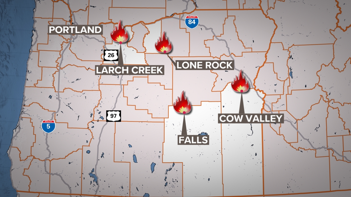
- Location: Wasco County, about 60 miles south of The Dalles, just east of the Mt. Hood National Forest.
- Acreage: 18,286 acres
- Cause: Believed to be human caused, still under investigation.
- Began: July 9
- Containment: 81%
- Closures: None currently
- Evacuations: Level 2 evacuations are still in place in two areas, but all other prior notices have been lifted. Visit the Wasco County Sheriff's Office Facebook page for more details.
- More info: Visit the Larch Creek Fire information page on Facebook or go to the Larch Creek Fire's entry on Inciweb.
Falls Fire
- Location: Harney County, about 15 miles northwest of Burns, inside the Malheur National Forest.
- Acreage: 114,236 acres
- Cause: Believed to be human caused, still under investigation.
- Began: July 10
- Containment: 10%
- Closures: A significant portion of the southwest Malheur National Forest is closed, including about a dozen campgrounds.
- Evacuations: Evacuations are in place in Grant and Harney counties. Harney County has an interactive map of the evacuation zones.
- More info: Visit the Falls Fire information page on Facebook or go to the Falls Fire's entry on Inciweb.
Lone Rock Fire
- Location: Gilliam County, southeast corner near the border with Morrow County.
- Acreage: 83,922 acres
- Cause: Unknown, under investigation.
- Began: July 13
- Containment: 40%
- Closures: A portion of the northwestern Umatilla National Forest is closed.
- Evacuations: Level 3 evacuations are in place for residences south of Lone Rock, and in an area along the border with Morrow County. Evacuation centers have been set up at Memorial Hall in Condon, Heppner Elementary School and Wheeler High School, with a large animal shelter at the County Fairgrounds in Fossil.
- More info: Visit the Gilliam County Sheriff's Office Facebook page, the Central Oregon Fire Info website or the Lone Rock Fire's entry on Inciweb.
- Location: Malheur County, northwest of Ontario, about 30 miles from the Durkee Fire.
- Acreage: 133,408 acres
- Cause: Believed to be human caused, still under investigation.
- Began: July 11
- Containment: 77%
- Closures: No active closures.
- Evacuations: All evacuations for the Cow Valley Fire have been lifted.
- More info: Visit the Cow Valley Fire information page on Facebook or go to the Cow Valley Fire's entry on Inciweb.
Durkee Fire
- Location: Baker County, northwest of Ontario, about 30 miles from the Cow Valley Fire.
- Acreage: 116,431 acres
- Cause: Lightning
- Began: July 17
- Containment: 0%
- Closures: A section of the Burnt River Canyon road is closed to non-local and non-emergency traffic.
- Evacuations: Level 3 evacuations are in place for the Rye Valley area, as well as extended into rural areas of Willowcreek and Vale in Malheur County, with Level 2 and Level 1 evacuations in place nearby.
- More info: Visit Baker County Sheriff's Office Facebook page or go to the Durkee Fire's entry on Inciweb.
Salt Creek Fire (last update was July 17)
- Location: Jackson County, about 20 miles northeast of Medford.
- Acreage: 4,102 acres
- Cause: Believed to be human caused, still under investigation.
- Began: July 7
- Containment: 84% (mop-up phase)
- Closures: BLM-managed lands in the area are closed.
- Evacuations: Level 1 evacuations are in place in some areas around the fire.
- More info: Go to the Salt Creek Fire's entry on Inciweb.
Pilot Rock Fire (last update was 9 p.m. July 18)
- Location: Umatilla County, near Pilot Rock
- Acreage: 19,000 acres
- Cause: No information about the cause of the fire has been reported yet.
- Began: July 17
- Containment: No information has been reported about containment.
- Closures: Highway 395 from Ukiah, south of Pilot Rock, is closed with restricted access.
- Evacuations: Level 3 evacuations are in place. Shelters have been set up at the Pendleton Convention Center and Grant Union High School.
- More info: Visit the Umatilla County Sheriff's Office Facebook page.
Battle Mountain Complex (North Fork Owens Fire and Snake Fire)
- Location: Umatilla County, near Ukiah
- Acreage: 1,786 acres
- Cause: Lightning
- Began: July 17
- Containment: 0%
- Closures: Highway 395 from Ukiah, south of Pilot Rock, is closed with restricted access.
- Evacuations: Level 3 evacuations are in place west of Highway 395 between Ukiah and Dale.
- More info: Visit the Umatilla County Sheriff's Office Facebook page.