
WASCO COUNTY, Ore — Editor's note: Please see this page for updates on wildfires burning in Oregon.
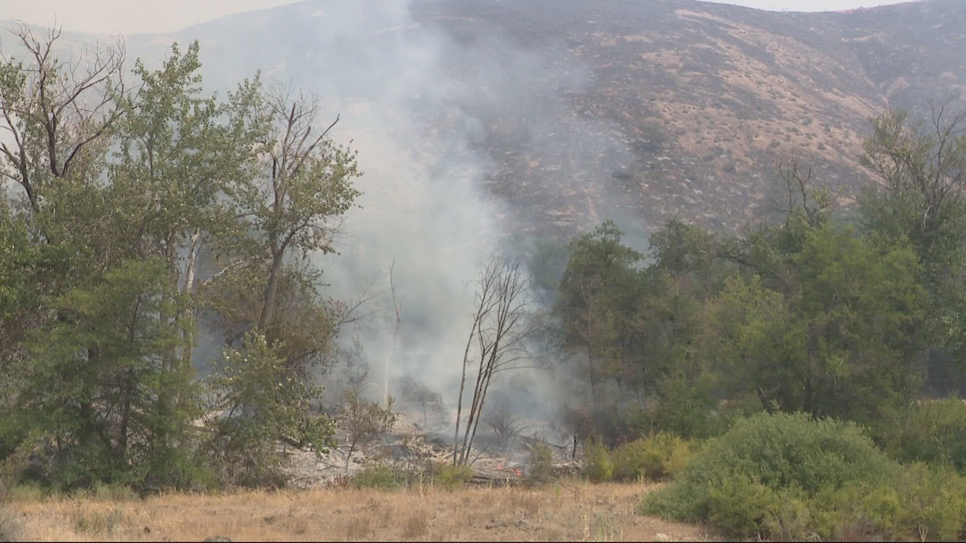
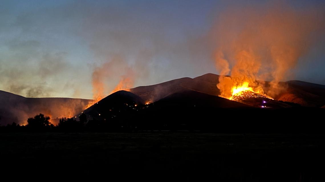
Crews are battling a wildfire burning near Friend in Wasco County, around 16 miles south of The Dalles. The Larch Creek Fire started Tuesday afternoon and has burned 18,486 acres, officials said Sunday. It is 3% contained.
A firefighter with heat-related injuries was taken to a hospital on Wednesday, the Oregon Department of Forestry said. The agency did not release any other details about the firefighter's injuries but said Thursday that they were doing well after being treated.
As of Thursday afternoon, no homes had been destroyed, but at least two outbuildings in the area had been destroyed by fire. The goal for crews on Thursday was to continue to protect homes, with over 1,000 in the area of concern.

“Our primary focus is the structures, and making sure it is all stable around that. Any fires that do pop up we try to extinguish and put out, but it’s more preparation, making sure the fire doesn’t get to those homes,” said Gert Zoutendjik, the Oregon State Fire Marshal's public information officer.
Meanwhile, more firefighters, task forces and some community members jumped in to battle the blaze Thursday.
Tygh Valley resident Mike Davis had flames come within feet of his home on Wednesday before fire crews and aircraft stopped the advance. Davis showed a KGW crew the fire retardant that had been dumped on his property, coating the ground, nearby vehicles and roofs in pink.
“What saved everything here was the amount of people that came in to help," Davis said. "It was unbelievable; we had more firefighters and hot spot guys. They were all over this — they jumped on it and got the DC-10s in, and it was amazing.”
Another Tygh Valley resident, Steven Kuhlman, told KGW this was one of the worst wildfires he had seen in the area. Kuhlman spent the day Wednesday helping crews fight the fire, and expressed concern about what could happen if wind gusts increased late in the afternoon on Thursday.
“If we get wind again, it can definitely get out of control again. If it stays like it is now, I think we are in pretty good shape, but if the wind comes up yesterday like it did and starts howling, it could be out of control again easily,” Kuhlman said.
RELATED: Larch Creek Fire continues burning in Wasco County; crews worried about hot, dry conditions
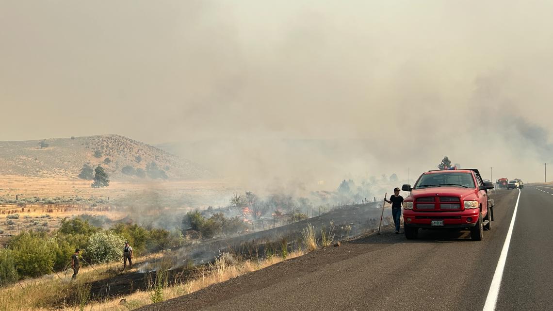
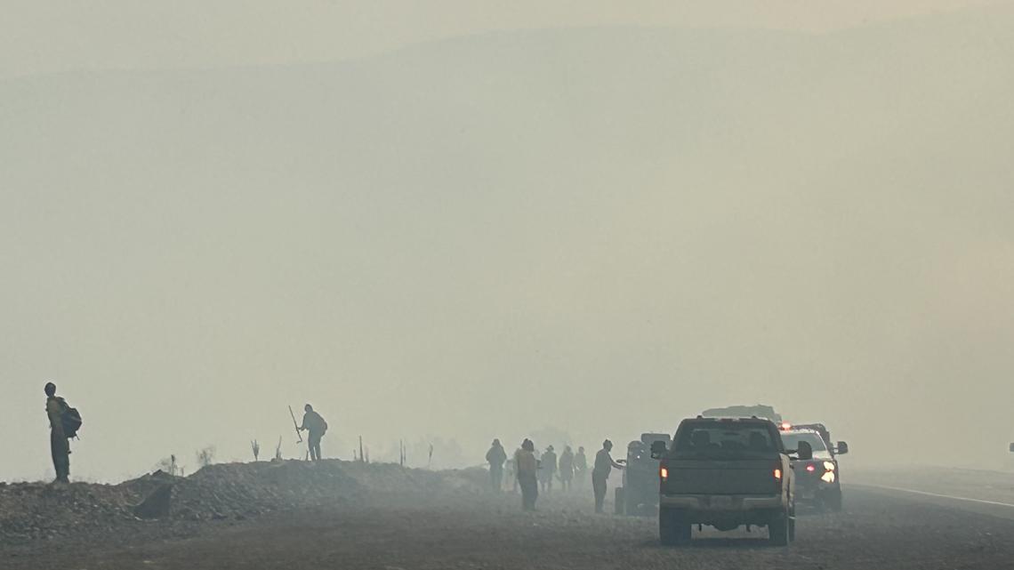
Winds were a concern throughout the week, but they subsided Wednesday evening, slowing the growth of the fire, according to the Oregon Department of Forestry. Dozers worked through the night and made progress while engines patrolled near homes in the area; structure task forces are continuing to mop up and secure nearby homes.
The Federal Emergency Management Agency (FEMA) has approved the state of Oregon's request for federal funds to help with firefighting costs.
Highway 216 East reopened on Friday evening after closing Thursday evening. Highway 197 is fully closed between the junction with Shadybrook Road in Tygh Valley at milepost 33 to Dufur Gap at milepost 36.

Evacuation orders have been issued for people living in the area. As of Wednesday afternoon, 41 homes have been evacuated.
- Level 3 "Go Now" evacuation orders have been issued for the Larch Creek Fire for Wamic and Pine Hollow, as well as residences from Friend Road, east to Elliott Road and Highway 197, south to Badger Creek Road, west to McCorkle Grade Road. The city of Tygh Valley, Highway 197, east to the Deschutes River, north to Hulse Road and south to Fred Ashley Road.
- Level 2 "Be Set" evacuation warnings have been issued for from the west border of Van Miller Roadd and north border to the White River, as well as the south border of Old Wapinitia Road and from intersection of Old Wapinitia Road to the Deschutes River at a northeast direction; north border is Oak Spring Rd on the east side of Highway 197. Leveel 2 warnings include White River, east to the Deschutes River, south to Oak Springs Road/Juniper Flat Road. Warnings have also been issued for Pine Hollow and Wamic from Badger Creek Road/Fairgrounds Road, south to Rock Creek Dam Road/Wamic Market Road, west to Threemile Road and east to Highway 197.
- Level 1 "Be Ready" evacuation warnings have been issued from Wamic Market Road/Rock Creek Dam Road, south to the White River, west to Campbell Lane from Highway 197, east to the Deschutes River, south to Hulse Road from Elliott Road, east to Kinglsey Road/Dufur Gap Road, north to Friend Road and south to Level 3 border.
The Wasco County Fairgrounds is temporarily designated as an evacuation point for people and livestock. A Red Cross evacuation shelter is open at Maupin High School. Wy'East Middle School at 3000 Wy'East Road in Hood River is the designated shelter for people. Sherman County Fairgrounds is open for evacuation of livestock and pets, as well as Hood River Fairgrounds.
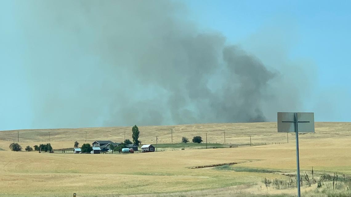
Meanwhile, near the town of Tygh in Wasco County, smoke sits in the valley, continuing to thicken throughout the morning, with some flames visible from miles away.
Some areas are contained by fire lines, though there's concern that the fire will continue to spread south on the grassy terrain, especially with winds picking up.
"It's our biggest concern. Even the winds now are only supposed to be 5 to 10 miles per hour. This afternoon, it's expected to pick up to 35," said Zoutedjik.
Crews will be digging fire lines, and aircrafts will dump water as long as it is not too windy, he continued. The Oregon Department of Forestry said that some spot fires are in the southern Oak Creek area. The fire is burning mainly in open grass fuel types, and aerial attack will be the primary resource, the agency said.
Officials said that fire was "human caused," though it's not yet clear how it started.
On Wednesday evening, state, local and federal resources will "work on transitioning night shift crews to day shift, while slowing progression towards Highway 197 and nearby Shadybrook community to the south," said the Oregon Department of Forestry.
The Central Oregon Type 3 Interagency Fire Management Team, as well as the Green Incident Management Team from the Oregon State Fire Marshal, are at the Dufur High School. Three more task forces are set to arrive in the afternoon.
READ MORE: Wildfire coverage from KGW News
Throughout Tuesday night, crews worked to put in dozer line and burnouts along the east and west flanks from the north down to the unsecured south.

On Tuesday evening, Oregon Gov. Tina Kotek invoked the Emergency Conflagration Act, which allows more fire support to assist local emergency responders battling the fire. The Oregon State Fire Marshal (OSFM) mobilized its Green Incident Management team, along with four structural task forces.
Multiple air resources, eight fire engines, a 20-person U.S. Forest Service Mount Hood hand crew, four bulldozers and "local landowner resources" are battling the fire. A Type 3 Central Oregon Fire Management Service team has been ordered to assist. On Wednesday morning, Clackamas fire and Corbett fire posted video of fire trucks leaving to help fight the fire.
Meanwhile, the area remains under a red flag warning for critical fire weather, OSFM said.
"The heat wave that has gripped Oregon significantly increased the fire danger across the state. The continued hot, dry conditions, and gusty winds are a dangerous combination," said Chief Deputy State Fire Marshal Travis Medema in a release Tuesday evening. "I am asking everyone to do what they can to prevent sparking a wildfire."

Here's what evacuation levels mean
Level 1 Notice - Be Ready: Residents should be aware of the danger that exists in their area and monitor local media outlets for information. Residents with special needs should take note and begin making arrangements to evacuate. Evacuations at this time are voluntary.
Level 2 Notice - Be Set: This level indicates there is significant danger to your area, and residents should either voluntarily relocate to a shelter or outside of the affected area, or if choosing to remain, to be ready at a moment's notice. Emergency services cannot guarantee that they will be able to notify you if conditions rapidly deteriorate.
Level 3 Notice - Go Now: Danger to your area is current or imminent, and you should leave immediately. Listen to local media and watch for emergency personnel who may be coming by to give further instructions regarding the evacuation.
This is a developing story and will be updated with more information as it becomes available.
Download the KGW News app: Download for iPhone here | Download for Android here
Stream newscasts for free on KGW+ on Roku, Amazon Fire and Apple TV: How to add app to your device here
See a typo in this article? Email web@kgw.com for corrections.