Forecast
Weather Headlines
- Thursday showers followed by overnight rain
- Washington cities are recovering from the bomb cyclone. Here's when the next system arrives
- Stretch of I-5 from Ashland to the Oregon-California border reopens after winter-weather closure
- Volcano on Iceland's Reykjanes Peninsula erupts for the 7th time in a year
- Tree, power lines fall onto Kelso house during windstorm
- 'Bomb cyclone' kills 2 and knocks out power to over half a million homes across the northwest US
10-Day Forecast
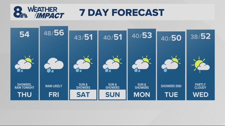
Thu
Nov 21
54
48
58%
7
MPH
ESE
Mostly cloudy. Highs in the low 50s and lows in the mid 40s.
84%
Low
7:19 AM
4:34 PM
Fri
Nov 22
56
43
58%
8
MPH
SE
A few morning showers. Highs in the mid 50s and lows in the mid 40s.
83%
Low
7:20 AM
4:33 PM
Sat
Nov 23
51
40
58%
7
MPH
SSE
Cloudy, periods of rain. Highs in the upper 40s and lows in the low 40s.
80%
Low
7:21 AM
4:32 PM
Sun
Nov 24
51
40
58%
7
MPH
SSE
Chance of showers. Highs in the low 50s and lows in the low 40s.
79%
Low
7:23 AM
4:31 PM
Mon
Nov 25
53
40
58%
9
MPH
SSE
Showers possible. Highs in the low 50s and lows in the upper 30s.
82%
Low
7:24 AM
4:31 PM
Tue
Nov 26
50
38
13%
4
MPH
E
Times of sun and clouds. Highs in the low 50s and lows in the upper 30s.
81%
Low
7:25 AM
4:30 PM
Wed
Nov 27
52
39
22%
4
MPH
SE
Cloudy. Highs in the upper 40s and lows in the upper 30s.
81%
Low
7:26 AM
4:30 PM
Thu
Nov 28
46
36
17%
5
MPH
ESE
More clouds than sun. Highs in the mid 40s and lows in the mid 30s.
79%
Low
7:28 AM
4:29 PM
Fri
Nov 29
44
35
18%
6
MPH
E
Partly cloudy. Highs in the mid 40s and lows in the mid 30s.
77%
Low
7:29 AM
4:29 PM
Sat
Nov 30
44
34
24%
7
MPH
E
Partly cloudy. Highs in the mid 40s and lows in the mid 30s.
69%
Low
7:30 AM
4:28 PM
Hourly Forecast
2 PM
Thu
51°
2%
7
MPH
E
3 PM
Thu
51°
2%
7
MPH
E
4 PM
Thu
50°
3%
8
MPH
ENE
5 PM
Thu
49°
3%
7
MPH
ENE
6 PM
Thu
48°
3%
7
MPH
ENE
7 PM
Thu
47°
4%
8
MPH
ENE
8 PM
Thu
47°
10%
8
MPH
ENE
9 PM
Thu
48°
21%
10
MPH
ENE
10 PM
Thu
48°
35%
10
MPH
ENE
11 PM
Thu
49°
64%
11
MPH
ENE
12 AM
Fri
49°
89%
12
MPH
ENE
1 AM
Fri
49°
99%
11
MPH
ENE


