PORTLAND, Oregon — Multiple atmospheric rivers set to arrive in the coming days will bring several inches of rain to Portland and snow in the Cascades through Monday.
Three atmospheric rivers are expected to hit the Pacific Northwest between Friday and Tuesday, according to KGW Chief Meteorologist Matt Zaffino.
What exactly is an atmospheric river? Below is an explanation on what they are, plus the rain totals the Willamette Valley could see and the snow levels expected in the Cascades.
What is an atmospheric river?
Atmospheric rivers is a newer name for a weather pattern in the Pacific Northwest called a Pineapple Express. They are long, narrow regions in the atmosphere that transport moist air from the tropics to higher latitudes, according to the National Oceanic and Atmospheric Administration (NOAA).
The plumes of precipitable moisture are often formed in areas just north of Hawaii and channel directly into the Pacific Northwest. They often release water vapor in the form of heavy rainfall and high snow levels. Atmospheric rivers can result in flash flooding and mudslides.
How much rain could fall in the Willamette Valley?
Total rainfall between Thursday and Monday could reach four inches in Portland, according to KGW meteorologist Rod Hill.
Rainfall will start off small on Thursday, with a quarter-of-an-inch expected in the Rose City and a half-inch on Friday. A long stretch of steady, heavier rainfall arrives Saturday afternoon through Sunday afternoon. Two inches or more of rainfall is expected.
"High water spots and ponding of water over roadways may become a hazard," Hill said.
Monday is expected to be much drier, but heavier rain will return Tuesday afternoon through Wednesday. Hill said he expects an additional inch of rain to fall.
The graphic below shows the rain potential around the Willamette Valley.


How much snow could fall in the Cascades?
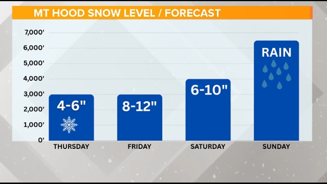
A total of approximately 30 inches of snow could fall at Mount Hood ski resorts, but upcoming days of rain will wash most of it away, according to Hill.
A Snow Advisory will be in effect for the Cascades and Mount Hood through Thursday evening. The advisory will be upgraded to a Winter Storm Warning overnight through the day Saturday as heavier snow arrives, Hill said.
Snow levels on Mount Hood will remain below the Cascade passes at 3,000 feet through noon on Saturday. Government Camp could see a wet mix in the afternoon as snow levels rise to 4,000 feet. By Sunday morning, rain will fall up through 6,000 feet at Timberline Lodge. The Cascades will see all rain Monday through Wednesday, with snow levels as high as 8,000 feet, Hill said.
The graphic below shows daily snowfall amounts on Mount Hood through Sunday.


