WOODLAND, Wash — A project to repair the North Fork Lewis River Bridge near Woodland is creating major backups and delays on southbound Interstate 5. But in a news release Monday, the Cowlitz County Sheriff's Office warned drivers that their best course of action is to ride out the jam and ignore any tempting detour routes suggested by GPS navigation services.
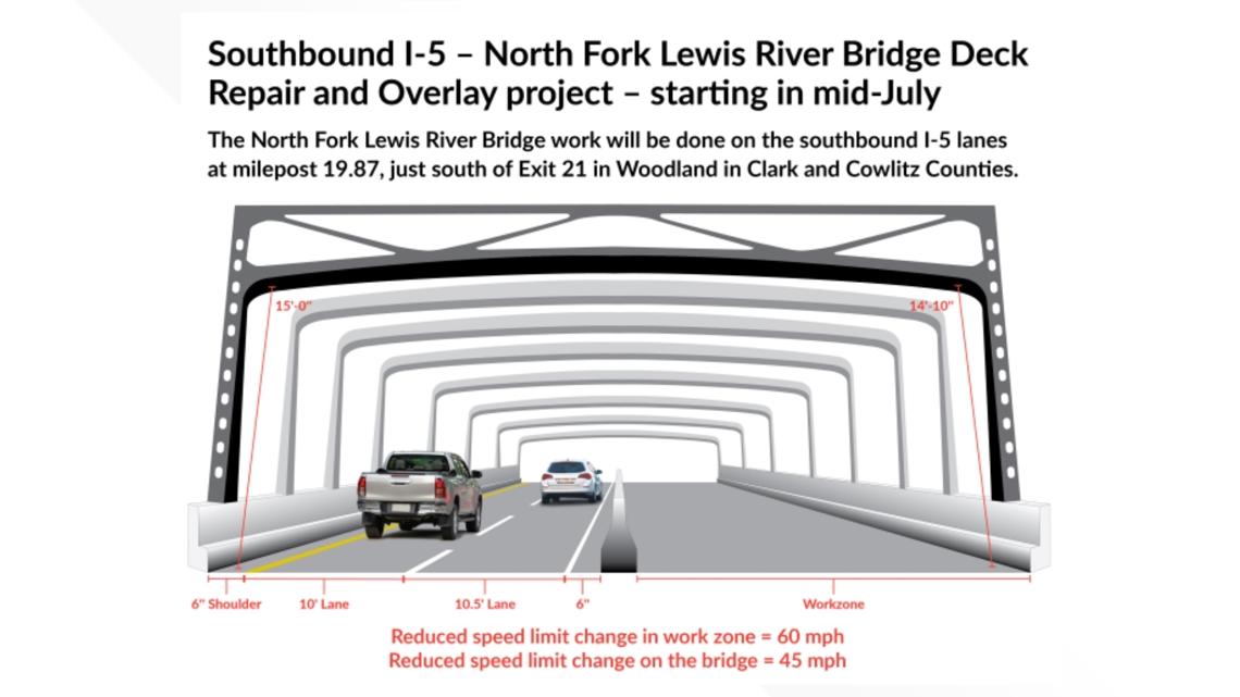
The repairs began earlier this month and will keep one of the bridge's three southbound lanes closed 24/7 until September. The two remaining lanes have also been narrowed and the speed limit on the bridge has been lowered to 45 mph. Drivers should expect delays of up 70 minutes at peak hours, according to the Washington State Department of Transportation.
During these traffic backups, Google Maps and Waze have started telling drivers to take a shortcut where they exit the freeway about eight miles north of the bridge near Kalama and follow Cloverdale Road and Green Mountain Road before looping back to rejoin I-5. Because of the length of the backups, the apps claim the detour is faster, even though it's longer.

But there are a few problems with that, according to the sheriff's office. For starters, the detour route doesn't actually bypass the work zone; it reconnects with I-5 in Woodland one mile north of the bridge, so it adds constant stream of cars trying to merge onto the freeway right where the cars already on I-5 are trying to zipper merge down to two lanes.
Green Mountain Road is also a small and steep road with a lot of tight turns, the sheriff's office added, so it's only meant for local traffic and deliveries. The detour drivers are creating severe congestion for residents along the route, and several vehicles with trailers have gotten stuck on the turns, making things worse.
The sheriff's office will place extra deputies near the detour exit near Kalama, and WSDOT has also reached out to Google Maps and Waze to try to get the apps to stop recommending the route, but so far the companies have not done so.