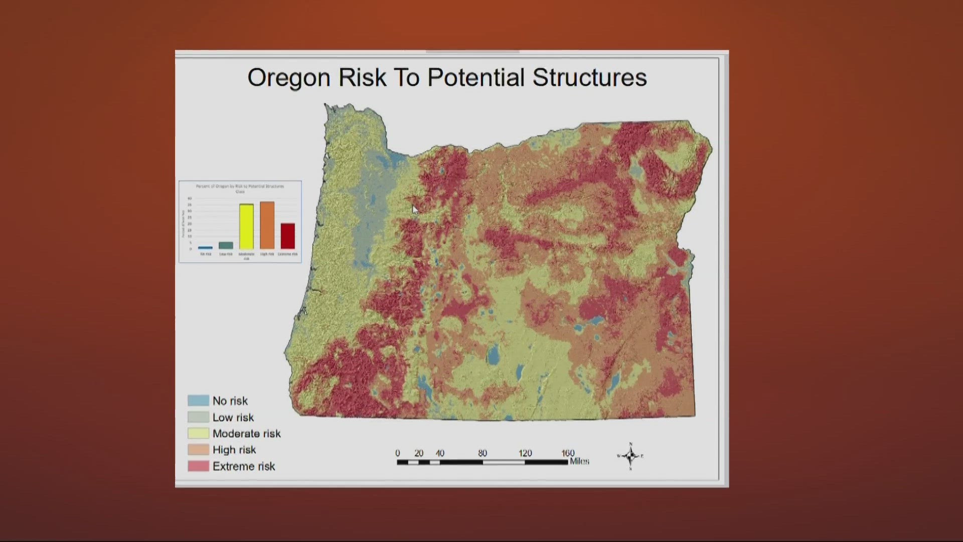
SALEM, Ore. — It’s that time of year when we’re thinking about wildfires, and right now the state is working on a map intended to help Oregonians know where the highest fire risks are.
That said, there have been some arguments over this particular initiative over the last couple of years — this will be the second go-round for a map like this.
The Oregon Department of Forestry and Oregon State University have been working with lawmakers for the last two years to put together a map that will improve wildfire preparedness after the first one got sent back to the drawing board.
In 2021, the Oregon Legislature passed Senate Bill 762, which was going to address multiple wildfire issues in Oregon and establish some wildfire programs. It was passed to help to develop a safe and effective response to wildfire dangers.
One aspect of the bill was a map outlying five different levels of risks, from "no risk" to "extreme risk."
But almost immediately after the map came out, homeowners began reporting that their insurance rates were skyrocketing as a result, especially in rural areas of the state. Some reported they'd actually been dropped by their insurance providers.
People began flooding ODF with negative feedback during public comment. State officials abruptly pulled the wildfire risk map, promising that it would get a closer look.
“There was some misunderstanding about the map and the risk it posed for individual properties and communities,” said Derek Gasperini, a spokesperson with Oregon Department of Forestry.
In this past legislative session, lawmakers passed Senate Bill 80 and made revisions to the map program. Some of the changes are pretty minor.
“To change the name to a 'wildfire hazard map' to better illustrate the purpose of the map, which is to educate people about what hazards wildfires might pose to their areas," Gasperini said.
He said the new map is going to have three levels: low, moderate and high risk. The map will allow Oregonians to see where the highest risk of wildfires are, which are along the central and eastern side of the state and down into southern Oregon.
“The legislature did pass pass Senate Bill 80 in 2023, prohibiting insurance companies using this statewide map for any insurance purposes for determining rates,” Gasperini said.
Insurance companies have their own maps and polices they use when determining insurance policies for homeowners.
This new map isn’t complete just yet. The Oregon Department of Forestry plans on holding community meetings throughout the state to hear from property owners. That’s not expected to start taking place until later this year or the beginning of 2024.
Here’s a look at what Senate Bill 80 does to change the wildfire map, according to state officials:
- Clarifies the purpose of the map as being a tool to:
- Inform Oregon residents and property owners about their wildfire exposure by providing transparent and science-based information.
- Assist in prioritizing fire adaption and mitigation resources for the most vulnerable locations.
- Identify where defensible space standards and home hardening codes will apply.
- Changes from five “risk” classes to three “hazard” classes.
- Requires eight meetings with county and local officials to review local draft maps.
- Limits the hazard class notification requirements to those in high hazard zones that are also inside wildland-urban interface boundaries. Updated notifications will be reviewed by the Wildfire Programs Advisory Council for recommendations on tone, clarity of language and presentation of information.
- Changes the appeal process: Properties in a high hazard class may be appealed as a contested case hearing described in Oregon Revised Statute Chapter 183.
ODF and OSU are still working on the process and timeline for revising the map. However, the following activities are planned:
- Complete a draft revision of the map that includes both previously voiced concerns and changes from SB 80.
- Attend eight county meetings across the state as described in SB 80 to share community-level revised maps with county representatives, gather local feedback, and provide clear information on how wildfire hazard is assessed.
- Convene a rulemaking advisory committee to amend the existing administrative rules to conform with the new law and incorporate lessons learned during county meetings.
- Schedule and attend community meetings across the state — with a focus on the highest hazard areas — to discuss how wildfire hazard was determined, what it means for property owners, share updated community-level draft maps, and get public input.
- Draft property owner notifications and solicit input from the Wildfire Programs Advisory Council.
- Publish a draft map online.
- Send notifications to property owners in high hazard zones inside the wildland-urban interface boundary, including instructions on how to appeal the designation.
- Publish the final map online, including the results of successful appeals.

