PORTLAND, Ore. — When the first ships arrived at the Portland waterfront for Fleet Week on Wednesday afternoon, they were greeted by dry skies. But while the midweek festivities have been lucky enough to enjoy some sunshine, this weekend's Rose Festival events are facing a soggier forecast.
An atmospheric river arrived Thursday evening, kicking off a stretch of on and off rain for the next three or four days that will extend this year's exceptionally cool and rainy spring season in the Portland region.
June is typically a pretty dry month, but Portland International Airport has recorded 0.81" of rain so far, and by the end of Sunday, the area is predicted to have received another 0.7", with other parts of the Interstate 5 corridor seeing as much as 1.1" and parts of the Cascades range seeing as much as 2.65".
What is an atmospheric river?
The culprit for the next round of rain is an atmospheric river forecasted to hit both Washington and Oregon in the coming days.
An atmospheric river is a long, narrow channel of water vapor in the atmosphere with a much higher moisture content than the surrounding air. It's a common weather phenomenon that transports moisture to areas outside of the tropics.
The strongest atmospheric rivers can carry an amount of water vapor roughly equivalent to the average flow of water at the mouth of the Mississippi River, according to the National Weather Service's description of the phenomenon.
The Portland region gets about 50-60% of its average annual rainfall from atmospheric river events, according to the Center for Western Weather and Water Extremes at UC San Diego.
A big plume of moisture out over the Pacific Ocean is expected to move eastward on Thursday, bringing a lot of rain to the Pacific Northwest starting in the afternoon.
There are several variables at play when discussing the intensity and potential impact of atmospheric rivers — projected rainfall rates, duration, and location — and these variables evolve over time.
Imagine aiming a garden hose at a lawn while opening and closing the spigot. If the hose is pointed in one place for a long enough time, it'll flood that part of the yard. This may seem obvious, but it's a good way to understand how impactful these system can be, and how dynamic they are.
The hose can drift north or south. The spigot can be opened further or closed. What's noteworthy about the one currently on its way is when it's occurring — less than two weeks from the summer solstice. Atmospheric rivers are much more common in the Pacific Northwest during the fall and winter months.
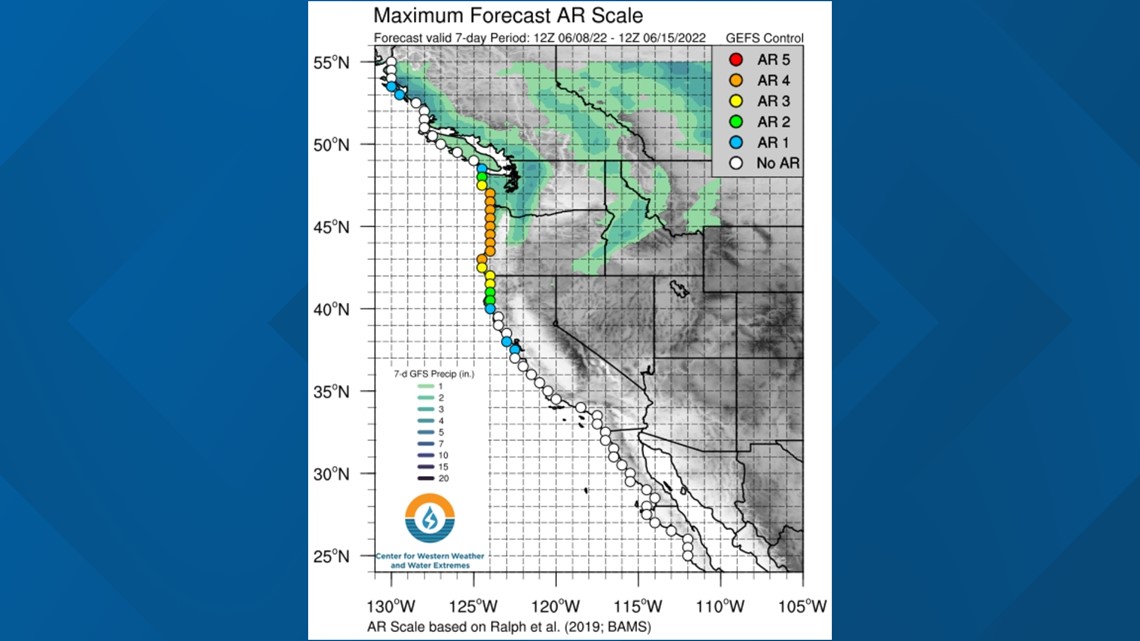
The projected intensity of this system is also noteworthy. A Wednesday forecast map from the Center for Western Weather and Water Extremes rated the predicted event as a 4 on the 0-5 Atmospheric River scale.


The scale is designed to be likened to categorization systems for other weather events, such as the Saffir Simpson scale for hurricanes and the Enhanced Fujita Scale for tornadoes.
Everyone has heard of an EF-4 tornado or a CAT-3 Hurricane, so this is an attempt to have similar understanding for one of the most frequent and impactful weather events on the West Coast.
The heaviest and steadiest rain is forecasted to hit Western Washington first on Thursday evening, closer to Seattle, but the system will later shift south and clip Portland as well.
The biggest round of rain will be Thursday night into Friday morning, but there's a chance of a second round of rain on the way for Friday afternoon and Saturday morning.

