AURORA, Ore. — At the Aurora airport, a twin-engine turboprop airplane taxied to the runway with limited visibility.
Smoke from Oregon wildfires choked the air.
This wouldn't be a leisurely flight, but one with a mission.
On board were members of the Oregon Department of Forestry and FLIR Systems, a Wilsonville infrared camera company.
Shortly after takeoff, any signs of the plane quickly disappeared into the smoky skies.
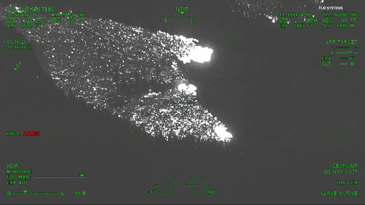
Underneath the plane, the Star Sapphire high definition camera descended from the plane's belly.
This isn't your normal camera.
"It's much different than what a camera would be on your phone or anything else," Marshall Grose, an applications engineering manager with FLIR Systems said, "We have multiple tools depending on conditions."
On this day, ODF is using the camera to get a look at the Beachie Creek Fire, the Riverside Fire and state parks in the area where the fire has burned or is heading toward.
"The smoke layer is large, thick and very heavy. Being able to penetrate through that smoke to get any image on the ground is extremely difficult and without specialized equipment like this, it's near impossible," Grose said.
From 12,000 feet up there's no chance of seeing active fire with the naked eye. The smoke layer is too thick to see anything below.
What the camera does do is help firefighters below by, "Trying to build that situational awareness for firefighters on the ground so they can have a better idea what the fire's doing, where it's at," State Aviation Manager Neal Laugle with the Oregon Department of Forestry said, "Are there any spot fires we're not aware of."
The flight was the fifth flight in the last few weeks for ODF, each flight circles the fires for a few hours.
"It's giving us a really good idea of how much fire there is, where the active spots are on the fire," Laugle said.
Tracking wildfires wasn't always this advanced, cameras like this weren't used 20 years ago when he first started.
"All the intelligence would be gathered with somebody trying to drive around in a pickup truck right now, finding fire edge and doing that. This allows us to get a good overview and we're not having to have folks drive that perimeter of the fire, trying to find all of this intelligence as well," Laugle said, "It was just flying around by visual sight in an aircraft and drawing on a piece of paper with a map and trying to hand draw something on a topographical map while flying around."
Time was wasted as the crews in the air had to wait to land and drive the current maps to command centers. Today's technology gives crews on the ground real-time information.
It's a new way to fight fires, using technology made by a company based in Wilsonville.
"Being able to get up and see through the smoke with that thermal imaging camera really helps. Define a picture and it helps the folks on the ground to know where they need to concentrate their efforts," Laugle said.